Summer Or Winter? Seasonal Confusion This Week
Sign up for the Morning Brief email newsletter to get weekday updates from The Weather Channel and our meteorologists.
A potent atmospheric river packing heavy rain will continue to hammer Northern California on Friday, possibly triggering more flooding, mudslides and rockslides as heavy snow piles up in the mountains.
Latest Status
This wet pattern was kicked off by a "bomb cyclone" that brought damaging winds to the Northwest, especially Washington, late Tuesday. See the bottom of this article for a recap on that chapter of the storm.
(MORE: 'Bomb Cyclone' Knocks Out Power To Hundreds Of Thousands)
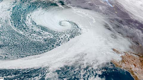
The biggest concern now is a potent atmospheric river of moisture that has already soaked Northern California the last couple of days. This band of moisture, which was reinforced by a second offshore storm, is expected to produce heavy rain and mountain snow through early Saturday morning, with the worst impacts affecting Northern California.
You can see where the rain and mountain snow is ongoing in the West right now in the radar snapshot below.
(MORE: Atmospheric Rivers 101)
Some areas of Northern California have picked up over 10 inches of rain since this siege began. The Sonoma County Airport in Santa Rosa had the city's heaviest two-day rainfall in 122 years, when almost 12 inches of rain fell from Wednesday through Thursday.
In all, there have been more than 100 reports of flooding, landslides and rockslides across Northern California in 72 hours ending Friday afternoon, according to National Weather Service storm reports. The blue icons plotted on the map of estimated rainfall below show where those reports are located in Northern California.
Forecast
The highest additional rainfall totals through early Saturday will be in Northern California generally along the I-80 corridor from the Bay Area to Sacramento and the Sierra foothills. Some of those areas could pick up another 3 inches or more.
This will result in flooding for poor drainage and urban areas as well as creeks and rivers. Mudslides may occur, especially in any recent wildfire burn areas. Rockslides are also possible along some mountain roads.
Elsewhere, lighter amounts of additional rain can be expected in western Oregon and western Washington going forward, with the heaviest amounts in coastal and foothill locations.
Additional systems this weekend into early next week will keep the West Coast unsettled with periods of rain and mountain snow. Winter storm warnings are in effect for parts of California's Sierra Nevada into early next week where snow totals will be measured in feet.
Bomb Cyclone Recap
The "bomb cyclone" that kicked off this stormy pattern on Tuesday night became one of the northeast Pacific's strongest storms on record, resulting in damaging winds across the Pacific Northwest.
(MORE: Bomb Cyclones 101)
The storm easily met the criteria for what meteorologists call bombogenesis, from where the term "bomb cyclone" originates. That means its pressure dropped by 24 or more millibars in 24 hours or less. This storm more than doubled that criteria.
Its estimated pressure dropped as low as 942 millibars, according to the 10 p.m. EST Tuesday analysis from NOAA's Weather Prediction Center. That's on par with an October 2021 storm (942.5 millibars) for the lowest pressure in about 50 years of records for that part of the northeast Pacific region. Since these are estimates, there is some uncertainty in the exact pressures.
Chris Dolce has been a senior meteorologist with weather.com for over 10 years after beginning his career with The Weather Channel in the early 2000s.